WATERFRONT
Featured
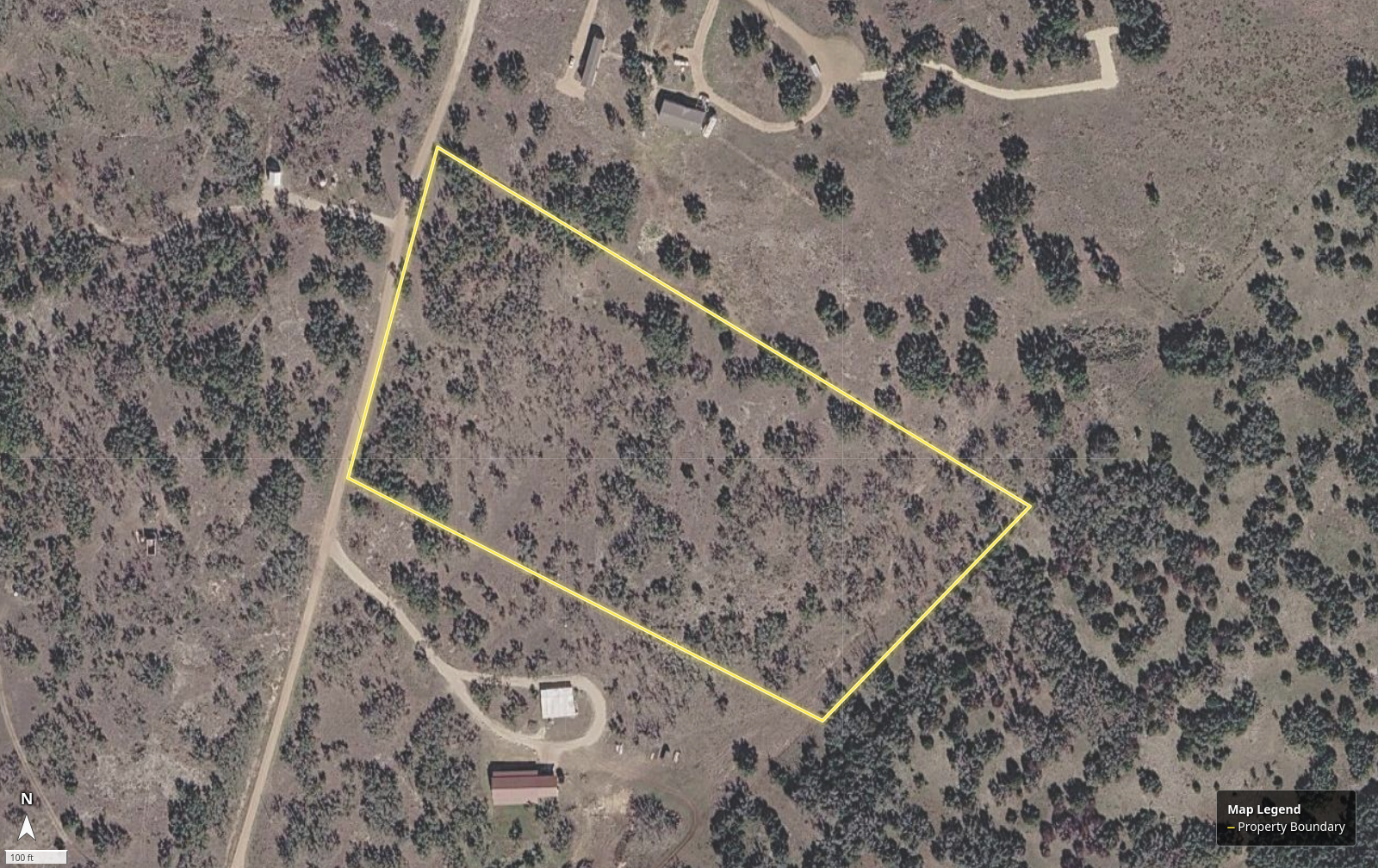
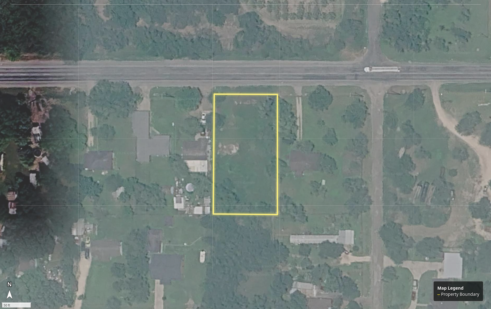
379 Bent Tree Ln
Harper, KIMBLE
10.58 ac
$500,001
$47,259 / acre • 147 days on market
1 creekNo flood0 ft frontage75% wooded25% brush35 ft elev
TexasParcels is a modern land marketplace that helps buyers, sellers, and brokers evaluate, list and sell Texas land with GIS-enriched parcel context.
Explore Texas land listings with richer parcel context, map visibility, and property details designed for land buyers.
$47,259 / acre • 147 days on market
$18,051 / acre • 154 days on market
$80,000 / acre
$1 / acre • 63 days on market
$3 / acre • 280 days on market
$1 / acre • 63 days on market
Advanced GIS intelligence and local insights, all in one platform.
Comprehensive land data and analysis.
Statewide coverage you can rely on.
Analysis-ready data for faster decisions.
Real people. Whenever you need us.
Know exactly how much road access a parcel has.
View nearby power, water, and utility infrastructure.
FEMA flood zones mapped with precision.
Understand slope, elevation, and topography.
Identify wooded areas and vegetation density.
Traditional listing sites often stop at acreage, photos, and basic location details. TexasParcels adds GIS context that helps buyers evaluate land faster and helps sellers present property more clearly.
View parcel boundaries, location context, and land-specific map layers that make land easier to understand.
Explore layersGive buyers better visibility into the property before the first inquiry with our standard attribute analysis.
See listingsBuilt specifically for Texas landowners, buyers, and brokers with a workflow designed around Texas land.
Why TexasMove from parcel review to market-ready listing faster with automatic enrichment built into the platform workflow.
View plansSee more than acreage and photos. TexasParcels helps buyers and sellers review land with parcel boundaries, high-resolution imagery, floodplain context, terrain visibility, and map layers that bring more clarity to every listing.
Texas land becomes easier to price, explain, and market when GIS context is built into the listing from day one.
Review county, acreage, imagery, and features while staying grounded in the geographic context that matters in land decisions.
TexasParcels is built to help users browse land in a more informed, map-first way.
TexasParcels helps every side of the land transaction work with better parcel context and a stronger land-specific workflow.
Review parcels with imagery, boundaries, floodplain context, and terrain before you inquire.
Learn moreTurn raw land into a buyer-ready listing with GIS context that helps explain and market the property.
Learn morePresent land more professionally with enrichment tools and a modern marketplace experience built for land.
Learn moreBuilt to help land listings communicate more clearly
TexasParcels combines listing visibility with parcel-level GIS context to help buyers review land faster and sellers market property with more confidence.
Use validated testimonials here once customer quotes are approved.
TexasParcels turns raw land into a listing buyers can understand faster, with GIS context that supports better land decisions.
Start with the land you want to review or sell by county, city, address, or mapped location.
Overlay parcel boundaries, imagery, floodplain, terrain, and map layers that explain the land more clearly.
Turn the parcel into a buyer-ready listing or use the enriched view to support pricing, marketing, and due diligence.
Start with GIS enrichment, upgrade to a full marketplace listing, or feature your parcel for stronger visibility when you want more exposure.
Analyze a land parcel with core GIS context before you market it, review it, or prepare it for sale.
Analyze your land parcel with GIS context and publish it as a buyer-ready land listing on TexasParcels.
Everything in the listing package plus stronger placement across the marketplace for added visibility.
The workflow is simple: find the parcel, enrich it with GIS context, and decide whether you want to publish it as a listing.
TexasParcels can layer parcel boundaries, imagery, floodplain context, terrain signals, and other mapped land data that helps buyers understand a tract faster.
Whether you are buying, selling, or preparing a parcel for market, TexasParcels helps you move from raw land to better decisions with GIS-enhanced property insight and a modern land marketplace experience.
Send a property question, seller request, or GIS enrichment inquiry and the team will follow up.